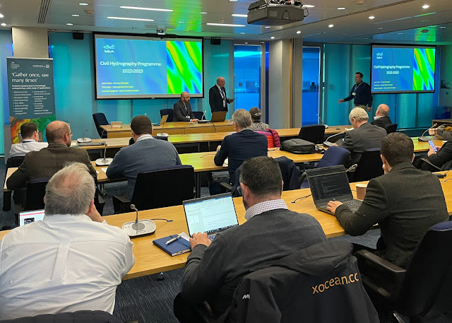
MCA seminar looks at all aspects of civil hydrography
Experts from across the UK will be gathering today (8 March) to discuss all aspects of the science that keeps mariners safe in its waters in an event organised by the Maritime and Coastguard Agency.
The MCA has overall responsibility for the UK Civil Hydrography Programme (CHP), which systematically surveys areas of highest navigational safety risk to provide high resolution data and information to keep the nation’s nautical charts and publications up-to-date.
Hydrographic survey work commissioned for the CHP is carried out by contractors, who gather and report seabed data. All CHP data is freely available and routinely used by other government departments, industry and academia for a myriad of applications.
Every year the MCA holds the Civil Hydrography Annual Seminar (CHAS), which provides an open forum for Government and industry to come together to report on surveys that have been completed and share their hydrographic data gathering and seabed mapping programmes for the forthcoming years.

As the largest commissioner of seabed mapping surveys in the UK, the MCA have a central role in identifying potential survey collaboration opportunities and integration of survey planning to maximise navigation safety and value for money.
In recognition that the MCA has overall responsibility for delivering the UK’s hydrographic obligations under the Safety of Life at Sea Convention (SOLAS), CHAS will be held at the International Maritime Organization’s building in London.
Maritime Minister Baroness Vere said: “The UK has world-class standards when it comes to maritime safety. Seabed mapping is important to maintaining those standards, helping us to keep our oceans safe and secure, protecting our seafarers, and supporting vital marine decision-making.
“Today's conference will allow industry leaders to bring their wealth of experience to the issue, exchange ideas, and explore how we can effectively use our resources.”
Andrew Colenutt, Head of Hydrography and Meteorology said: “As well as producing high resolution data that will be used to improve mariner’s safety and reduce navigation risk, the seabed mapping achieved through the CHP also combines the excitement of exploration and pushes the frontiers of technology and science.
“This seminar is an opportunity to bring the seabed mapping community together to explore the data we have acquired, to look at the ongoing mapping programmes and how best we can carry them out efficiently without jeopardising safety and – most importantly – how we can best continue to support the maritime sector.”
The MCA has overall responsibility for the UK Civil Hydrography Programme (CHP), which systematically surveys areas of highest navigational safety risk to provide high resolution data and information to keep the nation’s nautical charts and publications up-to-date.
Hydrographic survey work commissioned for the CHP is carried out by contractors, who gather and report seabed data. All CHP data is freely available and routinely used by other government departments, industry and academia for a myriad of applications.
Every year the MCA holds the Civil Hydrography Annual Seminar (CHAS), which provides an open forum for Government and industry to come together to report on surveys that have been completed and share their hydrographic data gathering and seabed mapping programmes for the forthcoming years.

As the largest commissioner of seabed mapping surveys in the UK, the MCA have a central role in identifying potential survey collaboration opportunities and integration of survey planning to maximise navigation safety and value for money.
In recognition that the MCA has overall responsibility for delivering the UK’s hydrographic obligations under the Safety of Life at Sea Convention (SOLAS), CHAS will be held at the International Maritime Organization’s building in London.
Maritime Minister Baroness Vere said: “The UK has world-class standards when it comes to maritime safety. Seabed mapping is important to maintaining those standards, helping us to keep our oceans safe and secure, protecting our seafarers, and supporting vital marine decision-making.
“Today's conference will allow industry leaders to bring their wealth of experience to the issue, exchange ideas, and explore how we can effectively use our resources.”
Andrew Colenutt, Head of Hydrography and Meteorology said: “As well as producing high resolution data that will be used to improve mariner’s safety and reduce navigation risk, the seabed mapping achieved through the CHP also combines the excitement of exploration and pushes the frontiers of technology and science.
“This seminar is an opportunity to bring the seabed mapping community together to explore the data we have acquired, to look at the ongoing mapping programmes and how best we can carry them out efficiently without jeopardising safety and – most importantly – how we can best continue to support the maritime sector.”


Comments
Post a Comment